Question 1. Choose the right answer from the four alternative given below:
(i) The Tropic of Cancer does not pass through.
(a) Rajasthan
(b) Chattishgarh
(c) Orrisa
(d) Tripura
Answer : (c) Orrisa
(ii) The easternmost longitude of India is-
(a) 97° 25'E
(b) 68° 7' E
(c) 77° 6' E (d) 82° 32'E
Answer : (a) 97° 25'E
(iii) Uttarakhand, Uttar Pradesh, Bihar, West Bengal and Sikkim have common frontiers with
(a) China
(b) Bhutan
(c) Nepal (d) Mayanmar
Answer : (c) Nepal
(iv) If you intend to visit Kavarati during your summer vacations, which one of the following Union Territories of India you will be going to-
(a) Puducherry
(b) Lakshadweep
(c) Andaman and Nicobar (d) Diu and Daman
Answer : (b) Lakshadweep
(v) My friend hails from a country which does not share land boundary with India. Identify the country.
(a) Bhutan
(b) Tajikistan
(c) Bangladesh (d) Nepal
Answer : (b) Tajikistan
Question 2. Answer the following questions briefly.
Question (i).Name the group of islands lying in the Arabian sea.
Answer : Lakshadweep in Arabian sea.
(ii). Name the countries which are larger than India.
Answer : Russia, Chand, USA, China, Brazil, Australia.
(iii). Which island group of India lies to its south-east?
Answer : Andaman and Nicobar island.
(iv). Which island countries are our southern neighbours?
Answer : Lakshadweep in Arabian Sea.
Question 3. The sun rises two hours earlier in Arunachal Pradesh as compared to Gujarat in the west but the watches show the same time. How does this happen?
Answer : India has longitiudinal extent of 300. Due to this there is a time lag of two hours between the sunrise on the easternmost and the westernmost horizons of India. due to rotation, the earth takes 4 minute to rotate through 10 of longititude. In covering 300 of longitiudinal extent, there is difference in time lag of 2 hours. When it is 6 a.m in Aruanchal Pardesh, it is still 4 a.m in Gujrat and jasalmer. but the watches in all parts are run according to standard time measured from 82 1/2 00 E longitude. So the watches in Arunachal Pradesh and jaisalmer show the same time despite to different sunrise.
Question 4. The central location of India at the head of the Indian Ocean is considered of great significance. Why?
Answer : The central location of India at the head of the Indian Ocean is considered of great significance because :
- It provides India with abundant extended sea routes to apply her trade and common devices/strategies with developed countries (West European) at her left hand and developing countries. (Orient Asian) at the right.
- It helps India, flowing her stream of wisdom in physical, mental, emotional and psychological fields everywhere in Africa, Asia and Europe continents. It includes spiritual, technical, physiological, anatomical and material (bilateral trade on goods, metals etc.) Knowledge also. India is Jagatguru and Rigveda is the foremost pre-historic scripture in the world - these couple of facts prevail.
- India holds title authority on India Ocean. In fact, India only has the longest coastline (West and East) in the above said ocean in the world.
Things to remember About India:
- Total Geogrophical Area: 32,87,263km.2
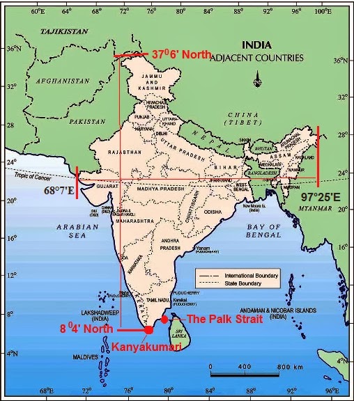
- Latitudinal extent: 804' North to 3706' North.
- Longitudinal extent: 6807' East to 97025' East.
- North-South extent: 3214 kms.
- East-West extent: 2933 kms.
- Land Frontiers: 15,200 kms
- Coastline: 7,516 kms.
- Standard Meridian: 82 1/2 0 East longitude.
- Southern most point: Indira point.
- Southernmost tip of mainland: Kanyakumari.
- Number of States: 28
- Number of Union Territories: 7
- The Largest State: Rajasthan.
- The smallest State: Goa.
Map Skills
Question.1: Identify the following with the help of map reading.
(i) The Island groups of India lying in the Arabian Sea and the Bay of Bengal.
Answer : Lakshadweep in the Arabian Sea; Andaman and Nicobar Islands in the Bay of Bengal
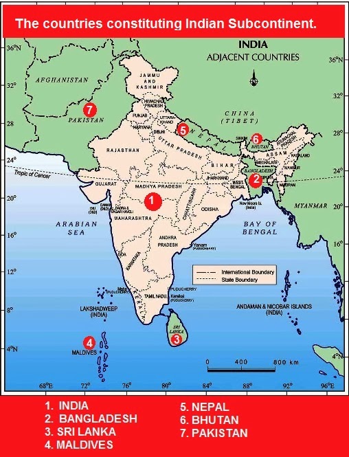
(ii) The countries constituting Indian Subcontinent.
Answer : Countries constituting Indian subcontinent are India at the core, Bangladesh in the east, Sri Lanka in the South (Island country in Indian Ocean), Maldives in South West (Island country in Indian Ocean), Nepal in the north, Bhutan in the north-east and and and Pakistan in the north-west.
(iii) The states through which the Tropic of Cancer passes.
Answer : Tropic of Cancer passes through the states of Gujarat, Rajasthan, Madhya Pradesh, Chhattisgarh, Jharkhand, West Bengal, Tripura and Mizoram.
(iv) The northernmost latitude in degrees.
Answer : 3706' North
(v) The southernmost latitude of the Indian mainland in degrees.
Answer : 804' North
(vi) The eastern and the western most longitude in degrees.
Answer : 6807' East to 97025' East.
(vii) The place situated on the three seas.
Answer : Kanyakumari
(viii) The strait separating Sri Lanka from India.
Answer : The Palk Strait.
(ix) The Union Territories of India.
Answer : There are seven Union Territories in India
- Andaman and Nicobar Islands
- Chandigarh
- Dadra and Nagar Haveli
- Daman and Diu
- Delhi (National Capital Territory of Delhi)
- Lakshadweep
- Puducherry (Pondicherry)
Chapter 1 India : Size and Location | Geography | Class IX (9th) CBSE | Solved Exercises


very helpful to me
ReplyDeletethankyou!!
ReplyDeleteVery cool
ReplyDeleteThxxx.....
ReplyDeletebut it has many mistakes in it did you notice
DeleteHow are we supposed to put that in one map
ReplyDeleteThank u very much
ReplyDeleteTanq
ReplyDeleteThank u very much
ReplyDeleteVery helpful
ReplyDeleteIn question number 3, how it is longitudinal extend,it can also be measure as latitudinal extent of 30 degree i.e. 68.7 degree to 97.25 from west to east, due to this reason there is a time lag of two hours between the sunrise on the easternmost and the westernmost horizons of India.
ReplyDeleteHelpful..
ReplyDeleteVery helpful to me
ReplyDeleteVery helpful...Thanku ...And plz post like this for other chapters also😀😄😄
ReplyDeleteThank you
ReplyDeleteVery helpful for me
ReplyDeleteThanks so much
ReplyDeleteThanks you so much. It is very helpful for me.I wish that you will post more like this.
ReplyDeleteThank you
ReplyDeleteThanks
ReplyDeleteThanks
ReplyDeleteThanks for everything
ReplyDelete1
Tnksss for this ������
ReplyDeleteThank u so much
ReplyDeleteThank u so much
ReplyDeleteHelp given at right time
ReplyDeleteThank you
ReplyDeletethx
ReplyDeleteWhat ia the longitudinal and latitudinal extent of Bihar??
ReplyDeleteQ - 1 part 4 the southernmost neighbouring island countries are sri lanka and maldives not lakshadweep islands...
ReplyDeletethis is very useful thank you
ReplyDeleteLove you sir it's very helpful for me
ReplyDeletehow can i put all maps in one map?
ReplyDeleteThank you it is very helpful
ReplyDeleteThank you I have my exam tomorrow
ReplyDeletethanxxx....
ReplyDeleteThanks informative
ReplyDeleteVery most important maps skills questions for class9
ReplyDelete